
Geostatistics software, consulting & training for mining

From drill holes to resource models you can defend

Drill holes sample isolated points. They say nothing about what lies between them. Geostatistics estimates those gaps and measures the confidence of every estimate, so your resource model holds up in front of investors, boards and regulators.

What is geostatistics?

Geostatistics is the branch of statistics built for data spread across space. It starts from one plain observation: two samples taken close together are usually more alike than two taken far apart.

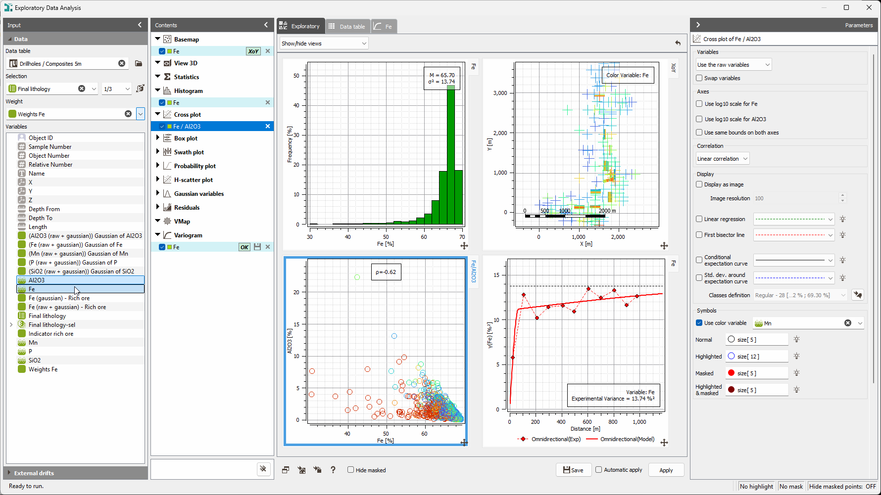
It measures that relationship, using a tool called the variogram, then puts it to work in two ways ordinary averaging cannot. It estimates grades between your drill holes, at every point in the deposit. And it quantifies how uncertain each estimate is, so you get the number and a measure of how far to trust it.

Because the model is built from your deposit's own spatial structure, the estimates are shaped by how your grades actually behave, not just by how many samples you have or where the drill pattern happens to fall.

Kriging, simulation and the variogram, explained in full
What is geostatistics?

What geostatistics changes for mining

What you gain

Resource estimates that survive scrutiny

Resource estimates that survive scrutiny

  • Same inputs, same result. Reproducible from one update to the next
  • Every parameter traceable, for investor and regulatory reporting
  • Built for resource statements reported under JORC, NI 43-101 and CIM
Fewer metres drilled, more confidence gained

Fewer metres drilled, more confidence gained

  • See where extra sampling genuinely reduces uncertainty, and where it only confirms what you already know
  • Set drill spacing before you commit the campaign budget
  • Turn each meter drilled into measurable resource confidence
Mine plans that account for what could go wrong

Mine plans that account for what could go wrong

  • Replace one grade model with a set of equally probable scenarios
  • Put numbers on NPV spread and downside risk before capital is committed
  • Align resource classification with mine planning from the start

Mining challenges we solve

Mining is decision-making under uncertainty. The question isn't whether your data has gaps. It's how well you measure them.

counter_1

"Our resource estimates swings between updates."

Swings erode credibility with investors and regulators. Kriging and conditional simulations produce estimates that are reproducible from one campaign to the next, traceable back to every parameter, and defensible under audit.

counter_2

"We're drilling too much, or in the wrong places."

Drilling is one of the largest line items in exploration. Geostatistical analysis shows where additional samples genuinely cut uncertainty and where they simply confirm what you already know. You set spacing deliberately, trim campaign cost, and get more resource confidence per metre drilled.

counter_3

"Our Measured / Indicated / Inferred split is hard to justify."

Classification carries direct financial and regulatory consequences. Geostatistics replaces the judgement call with auditable criteria (kriging efficiency, slope of regression and sampling density variance), all measures of how reliable and how well-informed each block estimate is. The split becomes a calculation you can show, not a position you have to argue.

counter_4

"Our mine plan has no view of the downside."

One grade model feeds one production plan and hides the range around it. Conditional simulations generate many equally probable grade models, so you can plan probabilistically, analyse the NPV distribution and price in risk before commitment rather than after.

Why geostatistics rather than conventional estimation?

Conventional methods - inverse distance weighting, nearest neighbour, polygonal estimation - decide how much each sample counts using geometry alone: how far away it sits, how the drill pattern is arranged. They never ask how your grades behave in space, because they have no way to measure it.

Geostatistics begins by measuring exactly that. The variogram gives you a model of the deposit's own structure, and every weight kriging applies is derived from it. The prediction is shaped by the variable, not by the sampling pattern.

Two things follow that conventional estimation cannot deliver. Every block carries its own confidence measure, so classification becomes a calculation rather than a position you defend. And simulations give you a quantified range of outcomes rather than one number with a caveat attached.

The practical difference: you stop defending an estimate and start presenting a distribution. That is what investors, boards and regulators increasingly expect.

Why geostatistics rather than conventional estimation? Why geostatistics rather than conventional estimation?

The advantages, in three layers

construction

Technical. Methods that match your geology

Kriging with local estimation variance, so every block carries its own confidence measure. Conditional simulations that reproduce your data's real spread and spatial structure instead of smoothing it away. Advanced geological modeling techniques for deposits whose geology is too intricate for standard methods. Sample clustering to separate tangled grade populations into workable domains. And variography done properly, because every estimate downstream depends on it.

computer

Operational. One workflow, start to finish

Drill-hole QC through to resource classification in a single platform, with reproducible workflows and complete audit trails. When a reviewer asks how a parameter was chosen, the answer is in the study. You do not rebuild it to find out.

savings

Business. Decisions that hold

Lower drilling and investigation spend, because sampling goes where it changes the answer. NPV and downside risk expressed as numbers rather than caveats. Classification decisions that stand up to audit. And resource statements your board, your investors and your regulator can act on without a second opinion.

From data to decision

Three stages. One platform. Full traceability.

01

From data to spatial model

Clean, validated data. A robust variogram. Estimation parameters you can justify.

02

From model to uncertainty

Reliable block estimates, local confidence intervals, probabilistic grade-tonnage curves.

03

From uncertainty to decision

Resource classification, drill campaign optimization, mine planning under risk.

Who gets the most from geostatistics

Resource geologists and competent persons

Producing reproducible, reportable estimates and defending the Measured / Indicated / Inferred classification in JORC, NI 43-101, and CIM statements.

Exploration geologists

Planning campaigns that pay: optimizing spacing and targeting sampling where it genuinely reduces uncertainty, so every metre drilled adds confidence.

Mine planners and engineers

Working with grade and risk together: building probabilistic mine plans and assessing NPV distributions before capital is committed.

Teams facing sparse or complex deposits

Data-scarce deposits where simulations build confidence from limited drilling. Geologically complex ones with intricate grade populations, multiple domains, or faulting. And any project needing independent review of an existing model.

And the moments that bring people here

A resource restatement that has to be defended. A feasibility study heading for board approval. External due diligence on an asset. A regulator or auditor questioning how a classification was reached.

Everything you need for confident subsurface decisions

Software, consulting, training

computer

Isatis.neo

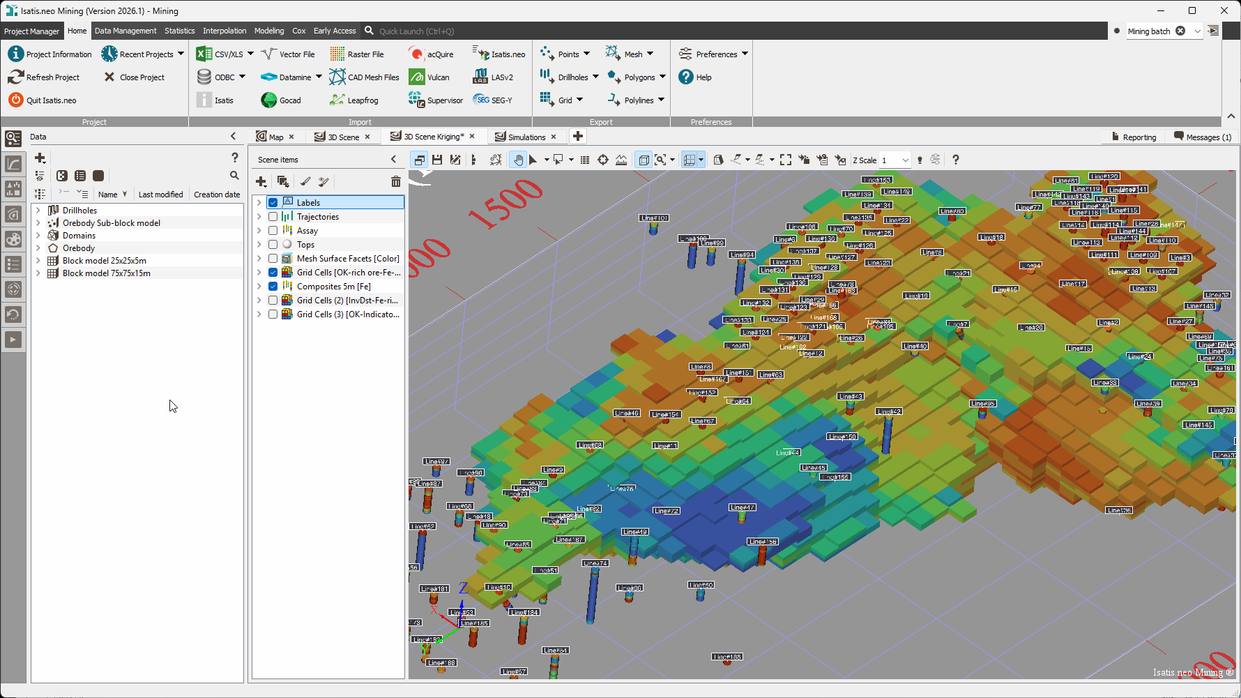
The reference geostatistics platform for resource geologists and competent persons. It covers the complete workflow from drill-hole QC to resource classification, with fully justified and traceable estimation parameters, complete audit trails, and reproducible workflows - everything a resource statement reported under JORC, NI 43-101 or CIM has to demonstrate.

Explore Isatis.neo arrow_forward
code_blocks

Isatis.py

Isatis.py brings Isatis.neo's geostatistical algorithms - kriging, simulation, variography, risk analysis - into Python. Automate complex workflows, embed spatial modeling in production pipelines, and combine geostatistics with your existing Python ecosystem. It works alongside Isatis.neo: scripting and automation in Python, guided modeling and visualization in the interface. Same algorithms, same results.

Explore Isatis.py arrow_forward
groups

Consulting

Our mining geostatisticians work alongside your team on resource estimation, domaining, variography and classification. We deliver complete studies for organizations without in-house geostatistics capability, and we take on discrete work for teams who have the skills but not the time. Independent review of an existing resource model is available as a standalone engagement.

See how we can help you arrow_forward
school

Training

Geostatistics training built specifically for mining, from resource-estimation fundamentals for exploration geologists to advanced conditional simulations and classification for competent persons. Delivered by practising geostatisticians on real mining datasets, online or in person, in English and French.

See our training arrow_forward
format_quote

"The 2023 mineral resource, estimated through Isatis.neo, resulted in a significant increase in the Life of Mine, enhancing the value of the company's mineral assets."

Rodrigo De Andrade Miotto – Specialist Geologist Mining Resources · Eurochem, Brazil
format_quote

"I used Isatis.neo to rotate a vein, which allowed me to increase kriging efficiency from 40% to 70%."

Antonio Umpire – Unit Manager Group Resource Estimation & Reporting · Sibanye-Stillwater, South Africa
format_quote

"I was surprised by how easily I stayed focused through two days of online training, even with the time difference. The theory was easy to grasp, and we applied it right away in the software. I can't wait to use it on a real project. The trainer is one of the best mentors and teachers: he knows the formula, the reasoning behind it, and how to apply it. I'll be back for another course."

Tatsky Reza Setiawan – VP Mineral Intelligence and Analysis · PT Mineral Industri Indonesia

Geostatistics for mining, in practice

How Imerys transforms data scarcity into a robust model through simulations Mining

How Imerys transforms data scarcity into a robust model through simulations

Faced with sparse drilling data in the northern extension of its Rodoretto talc mine, Imerys leveraged the advanced simulation capabilities of Isatis.neo, first using multiple-point statistics (MPS) and then plurigaussian simulations (PGS), to model lithologies and grades, with methodological support from Geovariances.

Read the full story arrow_forward
The Isatis.neo sample clustering tool identifies finely two complex geological domains in a platinum group metal deposit. Mining

The Isatis.neo sample clustering tool identifies finely two complex geological domains in a platinum group metal deposit.

Geological domaining is a crucial step in the resource modeling process. However, domains can be challenging to identify when grade populations are too intricate. Sibanye-Stillwater faced one such challenge for a PGM (platinum group metals) deposit with complex low-grade and very high-grade zones and several faults. They opted for the Isatis.neo clustering tool to overcome […]

Read the full story arrow_forward

Frequently Asked Questions

Everything you need to know before getting in touch

What is a variogram, and why does it matter so much? expand_more

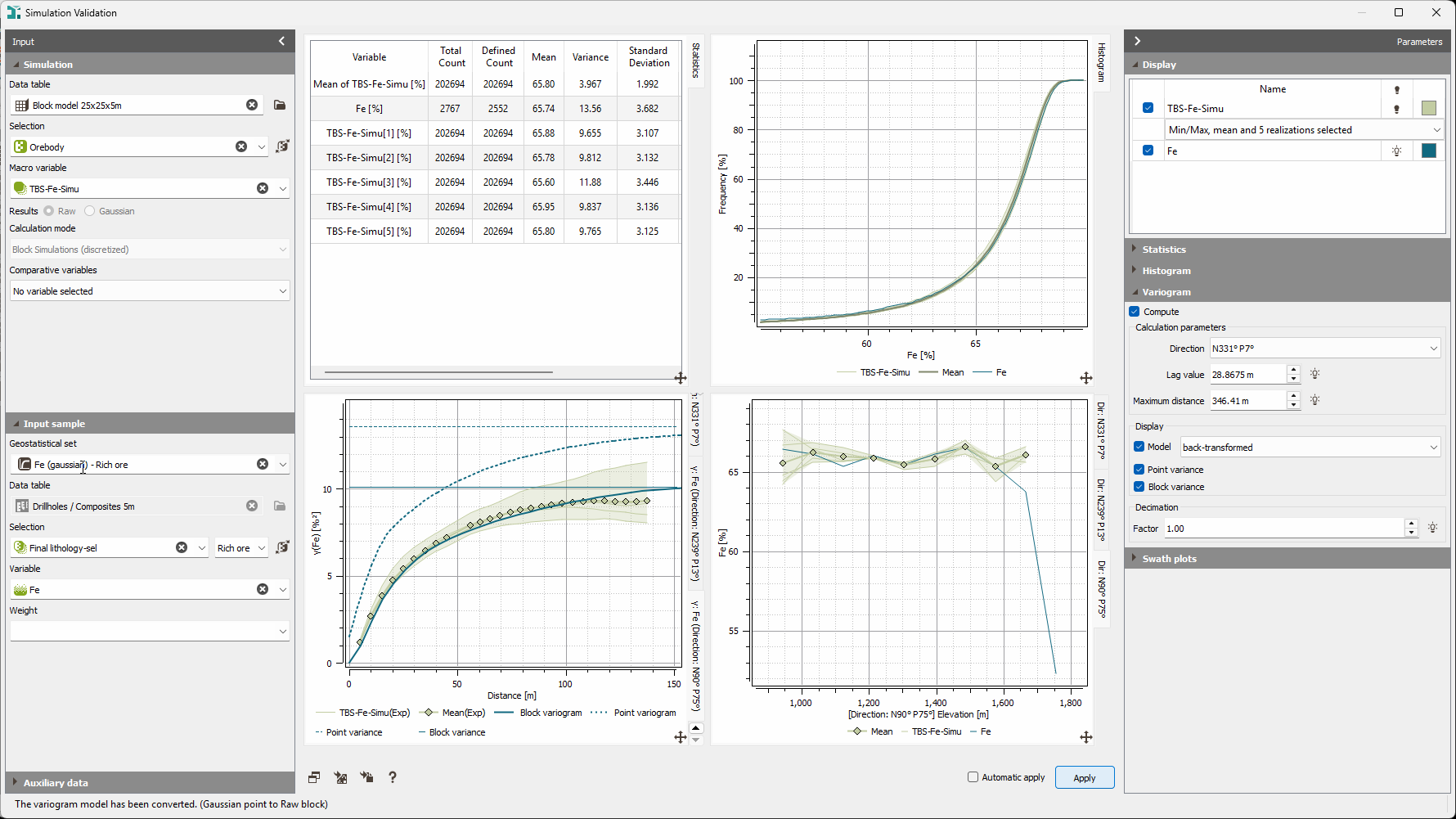
A variogram measures how quickly the similarity between two samples decreases as the distance between them increases, and how that varies with direction. It is the model of your deposit’s spatial structure, and both kriging and simulation derive their behaviour from it, meaning that an error in the variogram propagates into every estimate, every confidence interval, and every classification decision downstream. It is the step that most rewards experience, and the first thing an auditor or independent reviewer will examine.

What is conditional simulation, and how does it differ from kriging? expand_more

Kriging returns the most probable estimate at each unsampled location and minimises estimation variance. In doing so it smooths out the natural variability of the deposit, which makes it conservative and safe, and makes it a poor guide to anything that depends on grade variability. Conditional simulation generates many equally probable realisations of the grade distribution, each honouring the sample values and reproducing the statistical properties of the data, so the variability is preserved rather than averaged away. The trade-off runs both ways: kriging gives up realism for safety, and any single simulated realisation is a riskier estimate than the kriged one. Simulation’s value lies in the spread across all realisations, which is what risk quantification, planning under uncertainty and sensitivity analysis need. In practice the two are complementary: kriging for the reported estimate, simulation for the confidence around it.

How does geostatistics quantify uncertainty in resource estimation? expand_more

Geostatistics quantifies uncertainty through two complementary approaches. Kriging variance provides a local confidence indicator at every estimated block, showing how reliable the estimate is given the available data and the spatial continuity model. Conditional simulations generate a set of equally probable grade models, each honoring the sample data and reproducing the variogram, allowing you to compute grade-tonnage distributions, confidence intervals on resources, and NPV risk profiles. Together, they replace a single best estimate with a full probability distribution of outcomes.

Which should we use for our reported resource, kriging or simulation? expand_more

Kriging, in most cases. Its conservatism is a feature when a single defensible number has to be reported and defended, and its block-by-block variance supports classification directly. Simulation then sits alongside it, quantifying the uncertainty around the reported figure and supporting mine planning, cut-off decisions and NPV risk analysis. If you would like to discuss the right approach for a specific deposit, our geostatisticians can advise.

Can Isatis.neo support JORC, NI 43-101, and CIM standards? expand_more

Yes. Resource geologists and competent persons worldwide use Isatis.neo to produce mineral resource estimates reported under JORC, NI 43-101 and CIM. It provides fully justified and traceable estimation parameters, complete audit trails and reproducible workflows, all of which compliant resource reporting requires. For questions about a specific jurisdiction or reporting standard, our geostatisticians can advise you directly.

Move from a single estimate to a resource model you can defend

Talk to a Geovariances mining geostatistician about your deposit, your data and what you need to prove. No charge, no obligation.