Geostatistics for oil & gas, gas storage & geothermal
From seismic and wells to reservoir decisions you can defend
Subsurface decisions rely on incomplete data. Geostatistics integrates seismic, well, geological, and reservoir information to model spatial variability and uncertainty, helping teams assess plausible scenarios and make better investment decisions.
What is geostatistics?
Geostatistics is the branch of statistics designed for spatially distributed data. It uses the principle that observations separated by short distances are often more closely related than observations farther apart, while also accounting for geological trends, directional effects, and different scales of variability.
This spatial relationship is described using a variogram or another spatial model. It can then be used in two complementary ways:
Estimation: Kriging estimates properties at locations where no direct measurement is available. Depending on the data and modeling assumptions, it can combine information from wells, seismic data, and geological trends to estimate variables such as velocity, porosity, net-to-gross, saturation, or reservoir thickness.
Conditional simulations: Conditional simulations generate multiple spatial realizations consistent with the available data and the selected geological and spatial models. These realizations represent alternative plausible descriptions of the subsurface.
Analyzing them together makes it possible to quantify uncertainty in reservoir properties, geometry, connectivity, volumes, and decision thresholds.
Explore kriging, simulation and the variogram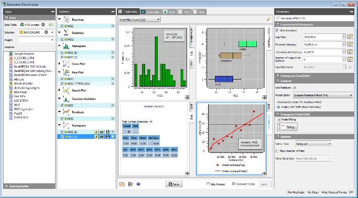
Why a single deterministic reservoir model is not enough?
A deterministic model can answer “what is the estimated reservoir volume?” It does not fully answer “How sensitive is that volume to uncertainty in the data, interpretation, and modeling assumptions?”
A single smoothed estimate can underrepresent extremes, connectivity, and spatial variability in a heterogeneous reservoir. It can also conceal alternative structural or geological scenarios that may lead to materially different outcomes.
Geostatistical simulation complements deterministic modeling by generating multiple plausible realizations. Statistics calculated across these realizations can provide:
– Percentile-based volume estimates such as P10, P50, and P90
– Probabilities of exceeding defined volume or property thresholds
– Maps of spatial uncertainty
– Alternative structural, facies, and petrophysical scenarios
– Comparable uncertainty ranges across prospects or assets
– A manageable set of scenarios for further testing
The objective is not to eliminate uncertainty. It is to understand it before it reaches a technical, operational, or investment decision.
Geostatistics changes what your energy decisions are based on.
What you gain
Volumes you can defend
- Probabilistic P10 / P50 / P90 ranges on in-place volumes (STOIIP for oil, GIIP for gas), not a single deterministic figure
- Probability of exceeding any rock- or hydrocarbon-volume threshold.
- Uncertainty propagated from reservoir geometry through to volumetrics

Models that honor every data source
- Well markers respected exactly
- Seismic, well, and geological trends integrated into one coherent model.
- Facies and petrophysics that reproduce real geological variability instead of smoothing it away.

Risk ranked before you invest
- Full traceability from raw seismic picks to the final decision
- Reproducible workflows any geoscientist can re-run without rebuilding the model
- Faster, directly comparable evaluations across a portfolio of prospects
Energy challenges we solve
You cannot remove subsurface uncertainty. The question is how well you quantify it before it reaches your volumes.
"Artefacts in our seismic survive standard filtering."
Acquisition footprints, patterns caused by oriented processing windows and coherent noise are spatially correlated, which is exactly what conventional filters miss. Wiener, median and F-k filters work on frequency content; factorial kriging (Matheron, 1982) works on spatial structure, so it removes an organised artefact without modifying the underlying signal. The same framework gives you an independent quality control of the processing chain: artefact magnitude can be quantified at any step, so data quality is reviewed independently of the processing that produced it. Filtering and QC apply to 2D and 3D grids and to scattered data such as seismic picks.
"Time-to-depth conversion adds uncertainty we never quantify."
The Conversions & Uncertainties workflow in Isatis.neo Petroleum Edition propagates uncertainty from seismic picking, velocities and depths through to gross rock volume — including fault positioning and spill-point recognition. Kriging with external drift and Bayesian kriging honour your well markers exactly while carrying a velocity trend. Because it is one platform rather than a chain of hand-offs, comparing conversion methodologies on the same case becomes an experiment you can run, not a project you have to fund.
"Our facies models don't reproduce real geological variability."
Facies simulation honours well data and follows 3D facies-proportion models. Plurigaussian simulation reproduces ordered sedimentary environments; multiple-point statistics reproduces complex geometries such as channels. Petrophysics is then populated facies by facies, with domain analysis detecting and correcting border effects across facies boundaries. Iterative post-processing integrates reservoir engineering results — observed connectivity between wells, for instance — so the static model is consistent with actual flow behaviour. That consistency shortens Production History Match and cuts the cost of the study.
"Our in-place volumes rest on a single model, with no uncertainty range."
Conditional simulation produces equiprobable 3D property distributions — porosity, net-to-gross, saturation — all conditioned to your well data. Statistics across that set give P10 / P50 / P90 ranges on rock and hydrocarbon volumes and the probability of exceeding any threshold. Kriging contributes the other half: its estimation variance defines confidence intervals around each estimated point, and that variance reflects both the number and the accuracy of the data sources you were able to integrate.
"We can't rank risk before an investment decision."
Realisations feed a global uncertainty assessment through Monte Carlo or Experimental Design methods, giving comparable, defensible ranges across prospects rather than hiding uncertainty inside a single number. The output that changes a decision is rarely the full realisation set. It is the small number of meaningfully different scenarios the set collapses into — two or three structural outcomes you can go and prove or disprove. That is a question a drilling programme can answer; "which of four hundred realisations is right" is not.
"We're characterising a geothermal or storage site from very few wells."
Sparse data is the condition geostatistics was built for, and the methods transfer directly. Kriging with external drift maps temperature or a reservoir property while honouring measured values at wells and following a regional trend. Conditional simulation quantifies uncertainty on capacity, on thermal resource and on the geometry of the containing structure. Typical geothermal work includes subsurface temperature mapping at regional or national scale, site-specific assessments for heat-pump feasibility, and thermal gradient estimation corrected for drilling and environmental effects.
The advantages, in three layers
Technical - Methods that match your subsurface
Conditional simulation; kriging with external drift and Bayesian kriging; plurigaussian and multiple-point facies simulation; factorial kriging for seismic QC; multivariate kriging to integrate wells and seismic data.
Operational - One platform, seismic QC to volumetrics
One platform from seismic QC to volumetrics, with fully traceable, reproducible workflows any geoscientist can re-run without rebuilding the model. Data exchange with Petrel®, and automation in Python via Isatis.py.
Business - Cases that hold up
Defensible P10 / P50 / P90 volumes and threshold-exceedance probabilities. Ranked, comparable risk across a prospect portfolio. Shorter Production History Match, and the study cost that comes with it. And structural scenarios reduced to a small number of testable hypotheses, so a drilling decision has something to answer.
From data to decision
Three stages. One platform. Full traceability.
From data to a spatial model
Seismic filtered and independently quality-controlled. Wells and seismic integrated. A structural and facies model you can justify.
From model to uncertainty
Equiprobable realizations on horizons, velocities, facies, petrophysics and gross rock volume.
From uncertainty to decisions
P10 / P50 / P90 volumes. Exceedance probabilities. A handful of scenarios you can test.
Who uses geostatistics in energy?
Reservoir geologists and geomodelers
Build facies and petrophysical models that represent geological heterogeneity, integrate well information, and provide alternative scenarios for reservoir assessment.
Geophysicists and seismic interpreters
Evaluate seismic attributes, support time-to-depth conversion, integrate well markers, and quantify uncertainty introduced by velocity and structural interpretations.
Reservoir engineers
Select geological and property scenarios for flow simulation and evaluate how uncertainty in the static model may influence dynamic forecasts.
Subsurface managers
Review volumetric ranges, compare prospects or scenarios consistently, and communicate geological uncertainty to partners and decision-makers.
Underground gas storage teams
Characterize reservoir properties and structural geometry, develop alternative geological scenarios, and provide uncertainty-aware inputs to capacity and dynamic-storage studies.
Geothermal project teams
Map temperature and reservoir properties, assess spatial uncertainty, and evaluate alternative resource scenarios from limited subsurface information.
Applying geostatistics in practice
Software, consulting, training
Isatis.neo
A geostatistical software platform for data analysis, variography, estimation, conditional simulation, uncertainty analysis, and risk assessment. The Petroleum Edition includes workflows designed for reservoir applications, including seismic time-to-depth conversion.
Explore Isatis.neo arrow_forwardIsatis.py
A Python library providing access to geostatistical algorithms for automation, reproducible studies, integration into data pipelines, and customized research or production workflows.
Explore Isatis.py arrow_forwardConsulting
Geovariances geostatisticians can support a complete study, contribute specialist expertise to a subsurface team, or independently review an existing model, methodology, or uncertainty assessment.
Discuss a consulting project arrow_forwardTraining
Training courses cover geostatistical principles and energy applications, from seismic-data quality control to reservoir simulation and uncertainty quantification.
Explore training arrow_forwardWebinars
Explore arrow_forwardDemos
Sign in arrow_forwardFrequently Asked Questions
Everything you need to know before getting in touch
How does geostatistics quantify uncertainty in in-place volumes (STOIIP / GIIP)? expand_more
Geostatistical simulations generate multiple reservoir realizations consistent with the available data and selected spatial models. Volumes are calculated for each realization, producing a distribution of possible outcomes. This distribution can be summarized using percentile-based estimates such as P10, P50, and P90 or probabilities of exceeding defined volume thresholds.
Why use kriging rather than a conventional seismic filter? expand_more
Conventional seismic filters commonly separate signal components using frequency or wavelength. Kriging-based methods can also analyze spatial continuity, direction, and scale. This can provide an additional way to identify spatially structured artefacts and assess how they affect interpreted data. The appropriate method depends on the type of noise, geological signal, and processing objective.
What does simulation-based facies modeling add compared with interpolation? expand_more
Interpolation generally produces one smoothed representation of the facies distribution. Simulation produces multiple possible configurations consistent with the wells, geological assumptions, and spatial model. These realizations can better represent uncertainty in facies geometry and connectivity and can be tested through volumetric or dynamic reservoir studies.
How is time-to-depth conversion uncertainty propagated into volumes? expand_more
Alternative velocity and depth models can be generated from seismic interpretations, velocity information, well markers, and structural assumptions. Gross rock volume or in-place volumes are then calculated for the resulting structural scenarios. This shows how uncertainty introduced during depth conversion contributes to the final volumetric range.
Can geostatistics be applied to underground storage projects? expand_more
Yes. Geostatistics can integrate sparse well, seismic, and regional information to model reservoir properties, structural geometry, and their associated uncertainty. The resulting geological realizations can support storage-capacity studies and provide representative inputs to dynamic storage simulation. Other disciplines remain necessary for flow, geomechanical, well-integrity, and containment assessments.
Can geostatistics be applied to geothermal projects? expand_more
Yes. Geostatistical methods can be used to map temperature, thermal gradients, geological structures, and reservoir properties from limited observations. Conditional simulation can quantify uncertainty in these variables and generate alternative resource scenarios for project evaluation.
Does geostatistics replace geological interpretation? expand_more
No. Geostatistics is commonly used to generate structural, facies, and petrophysical realizations that provide inputs to dynamic simulation. Reservoir simulation is then used to evaluate pressure and flow behavior. The two approaches address different but complementary parts of subsurface uncertainty.
How does Isatis.neo fit into an existing reservoir-modeling workflow? expand_more
Geostatistics can be introduced for a specific task, such as seismic quality control, depth conversion, facies simulation, property modeling, or volumetric uncertainty, or applied across a broader workflow. Data exchange and Python automation allow geostatistical analyses to complement established interpretation, geomodeling, and reservoir-simulation environments.
Understand the uncertainty behind your reservoir decision
Speak with a Geovariances geostatistician about your data, modeling assumptions, or uncertainty challenge. We will help you identify the most relevant methodological, software, training, or consulting approach.